|
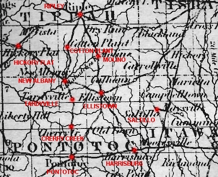
This map is a small portion taken from a complete map of Mississippi published by J.H. Colton & Co. of New York in 1855. The road running from Ripley through Molino and down to Ellistown and points beyond was known as the "Cotton Gin Road". The section of road from Ripley south to New Albany and on down to Pontotoc was known as the "Ripley-Pontotoc Road". Heading northwest out of New Albany towards Hickory Flat was the road known to locals as the "Memphis Road". There was no direct route to Oxford from New Albany in those days. Western Union County was largely impassable during the rainy season due to it being mostly bottom land with few connecting ridges. Another item of interest to me was the fact that I had never even heard of "Tandyville", shown just south of New Albany, until I saw this map! To even call these routes "roads" is somewhat misleading, for the most part they were only grass covered muddy ruts after a rain. If fact, the first "year round travel" gravel road to run through Union County, wasn't built until the late 1920's, today it's known as "Old Highway 15". If anyone reading this page knows the exact routing of the Ripley-Pontotoc road between Ripley and New Albany during the Civil War years please contact me. I have yet to find accurate information about it's location in those days and would like to know more. |